Tag:seamark:type=distance mark
 |
| Description |
|---|
| The distance measured from an origin on a waterway. |
| Group: Marine navigation |
| Used on these elements |
| Status: de facto |
| Tools for this tag |
|
How to map virtual distance mark
Set a node ![]() on the waterway (in the middle of the river) and add
on the waterway (in the middle of the river) and add
- seamark:type=distance_mark
- seamark:distance_mark:category=not_installed
- seamark:distance_mark:distance=* - number
- seamark:distance_mark:units=kilometres/hectometres

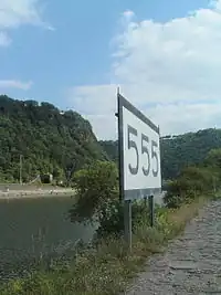
How to map the board
Set a node ![]() at the board and add
at the board and add
- seamark:type=distance_mark
- seamark:distance_mark:category=board
- seamark:distance_mark:distance=* - number
- seamark:distance_mark:units=kilometres/hectometres

See also
This article is issued from Openstreetmap. The text is licensed under Creative Commons - Attribution - Sharealike. Additional terms may apply for the media files.