GpsVP
| gpsVP | |
|---|---|
 | |
| Author: | Vsevolod Shorin |
| License: | BSD |
| Platforms: | Windows and Windows Mobile |
| Status: | Unmaintained |
| Version: | 0.4.24 (2012-02-05) |
| Language: | multiple languages |
| Website: | https://github.com/jerome077/gpsvp |
| Source code: | https://github.com/jerome077/gpsvp |
| Programming language: | C |
GpsVP is a GPS enabled application that can display vector based maps and raster maps.
Licensed under New BSD License.
It has built in support for
- loading OpenStreetMap tiles (offline or on demand over wireless network, if you wish)
- and Garmin format maps (also more than one at a time), various levels of detail, POIs
- It can also record tracks and store POIs.
- a search in OSM is available
- scanned maps can be displayed, prerequisites: georeferenced, tiled, config files
- Map or monitors view
- Remap Hardware Buttons to functions
The application runs on the WIN32-platform (PCs) and on many PocketPC/Smartphones with and without touchscreen.
Offical website: http://code.google.com/p/gpsvp/
The track formats available are GPX or Oziexplorer (*.plt).
Version 0.4.24 as of February 5th, 2012
- ...
Version 0.4.20 as of March 2nd, 2010
- tracks: now uses GPS time (subsecond) instead of system time
- sun azimuth
- navigate along predefined route
Example of use
 Ipaq mounted on bicycle
 Monitors view on a HTC S740 Smartphone. For each box the parameter shown can be configured. One needs to go into the setup and choose some options to get this view.
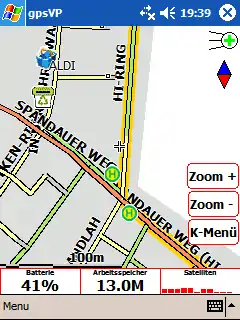 Vector map with marked cycle routes on pocket pc
Contact
Author?
This article is issued from Openstreetmap. The text is licensed under Creative Commons - Attribution - Sharealike. Additional terms may apply for the media files.